Page 5 of 5
Re: Metlink Local Travel Guides
Posted: Wed Nov 16, 2016 9:58 am
by Craig
November 2016 local area updates with the introduction of the new Cranbourne Bus Network on Sunday 13 November:
Casey -
https://static.ptv.vic.gov.au/siteasset ... ey_LAM.pdf
Frankston -
https://static.ptv.vic.gov.au/siteasset ... M_2016.pdf
Does not show 792 at Pearcedale
Greater Dandenong -
https://static.ptv.vic.gov.au/siteasset ... ng_LAM.pdf
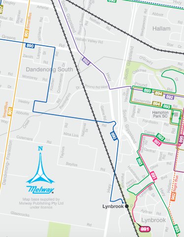
Unfortunately map still shows old 893 path through Hampton Park & Lynbrook and omits the 897 extension through Lyndhurst. The 691 extension to Monash Uni is still on the map 4 years and 11 months since it was deleted. The 891 terminus is also further south on the map than reality.
Updated maps for Cardinia, Knox, Mornington Peninusla not yet online.
Kind Regards
Craig

Re: Metlink Local Travel Guides
Posted: Tue Jan 03, 2017 11:31 pm
by howlerbus
I know its not quite Melbourne, but I have noticed that the Mildura network map has been updated to the current format
https://static.ptv.vic.gov.au/siteasset ... etwork.pdf
Re: Metlink Local Travel Guides
Posted: Thu Jan 05, 2017 2:02 am
by Heihachi_73
Are the maps at the bus stops themselves ever updated? The 742 has been showing the first stop from Eastland as "Ringwood Market" since forever, despite the market being closed down many years ago and having Costco built on the site. The "Ringwood Market" stop was also moved up about 100m near Churchill St but both the map and the timetable don't reflect this. In fact, quite a lot of the maps at bus stops in the area also have outdated bus routes e.g. 366/367/270 at Ringwood, and are still showing Metlink (just like this topic!) instead of PTV.
Re: Metlink Local Travel Guides
Posted: Thu Jan 05, 2017 3:57 pm
by Craig
Heihachi_73 wrote:Are the maps at the bus stops themselves ever updated? The 742 has been showing the first stop from Eastland as "Ringwood Market" since forever, despite the market being closed down many years ago and having Costco built on the site. The "Ringwood Market" stop was also moved up about 100m near Churchill St but both the map and the timetable don't reflect this. In fact, quite a lot of the maps at bus stops in the area also have outdated bus routes e.g. 366/367/270 at Ringwood, and are still showing Metlink (just like this topic!) instead of PTV.
The maps at the bus stops generally only got updated when the timetable on the other side of the case was updated. As you observed, often this meant another bus route nearby could change yet maps on unaffected routes became out-of-date.
In the last 2 years or so PTV has decided it has become all too hard and stopped installing and updating the local area maps at bus stops and instead has been installing generic information about how to use myki. Some SmartBus totems have a second generic sheet promoting the journey planner. This is a gradual update, usually occurring when there is a timetable change. although they seem to have replaced maps along the orbital routes in the last few months.
As for landmarks changing, PTV is also often slow in updating stop names when schools adopt a new name and even when they finally update the website, the signage may still reference the older name.
Kind Regards
Craig
Re: Metlink Local Travel Guides
Posted: Sun Jan 08, 2017 11:20 pm
by jamesadams7
For a long time, the bus stop name in front of Doncaster Shopping Centre remained as 'Doncaster Shoppingtown', despite that name disappearing after the last renovation about a decade ago. Even some bus destos today still display 'via Doncaster S'town'. Meanwhile, the main bus interchange for Brimbank Shopping Centre is called 'Brimbank Central SC/Neale Rd' despite the Central being dropped about 2 years ago.
Re: Metlink Local Travel Guides
Posted: Mon Jan 09, 2017 10:25 am
by krustyklo
For a long time, the bus stop name in front of Doncaster Shopping Centre remained as 'Doncaster Shoppingtown', despite that name disappearing after the last renovation about a decade ago. Even some bus destos today still display 'via Doncaster S'town'.
To be honest, I wonder if the destination 'Shoppingtown' is a reversion rather than an absence of change? Certainly when the centre owners started pushing the 'Westfield Doncaster' over the traditional name, the bus destinations mainly reflected this. Do they still do this? I have an appointment in the area on Friday so I'll keep my eyes open.
Certainly the name change had little traction, I heard a few people refer to 'Westfield' (all younger people) but most people still refer to it as 'Shoppo'.
Meanwhile, the main bus interchange for Brimbank Shopping Centre is called 'Brimbank Central SC/Neale Rd' despite the Central being dropped about 2 years ago.
To be fair, whilst I will happily criticise the PTV (and Metlink before it) for getting it wrong in the first place and seemingly having little or no error checking / quality control given the number of errors that seem to creep into their timetables, maps, stop information, flag descriptors, and other information products; I actually probably don't think it entirely fair that they should keep entirely up to date with every name change of every shopping centre, nor change signage every single time a shopping centre rebrands all at their own cost - unless it is being changed anyway when a quick check to make sure the name is still relevant seems fair. I assume the name still contains the words 'Brimbank' and 'Shopping Centre' so it is not particularly likely to confuse people, especially given the relatively recent change of name meaning people will still recall the old one (and probably still use it).
If shopping centre managements thought it important, they would make the effort to draw attention to the name change to all relevant authorities and include the cost of name changing other wayfinding signs such as bus stop signage, council finger pointers, etc in their budget for the rebranding. I wonder how many actually do this? If the answer is 'very few' or even 'zero' then clearly the main beneficiaries don't think it important, so not sure the PTV should go too far out of its way either unless there is genuine likelihood for confusion.
The bigger issue would be more likely community facilities that rebrand with a completely different name (eg, schools that rename themselves with more generic names to shake off their previous reputation) who may not have someone devoted to marketing or brand reputation on staff and are unlikely to think of this aspect of changing names outside of the immediate facility. I don't especially expect PTV to do this either, although in many cases here I expect there may be an internal list or expectation of reading the government gazette and making appropriate updates (eg, in the case of aforementioned school name changes).
Does anyone have any definitive info here about the internal processes ? (where is Revenue when you need him

Re: Metlink Local Travel Guides
Posted: Tue Jan 10, 2017 3:49 pm
by Heihachi_73
jamesadams7 wrote:For a long time, the bus stop name in front of Doncaster Shopping Centre remained as 'Doncaster Shoppingtown', despite that name disappearing after the last renovation about a decade ago. Even some bus destos today still display 'via Doncaster S'town'. Meanwhile, the main bus interchange for Brimbank Shopping Centre is called 'Brimbank Central SC/Neale Rd' despite the Central being dropped about 2 years ago.
The same applies to Westfield Knox, which is still called Knox City Shopping Centre even in the SmartBus PIDs. Of course, everyone still calls the place Knox City or just Knox. I have noticed that the maps I was talking about aren't as numerous as I thought - a number of the bus stops have nothing more than the timetable and a myki ad replacing the map.
Re: Metlink Local Travel Guides
Posted: Tue Jan 10, 2017 8:57 pm
by krustyklo
The same applies to Westfield Knox, which is still called Knox City Shopping Centre even in the SmartBus PIDs
I don't know that the PIDs have ever been seriously updated since the Smartbus routes were introduced. Certainly there are a number of anomalies on this basis. One example I can think of is that the Cook St stop on the 902 is still announced by Chelsea buses despite being moved west alongside the Coles and renamed as Plenty Rd not long after the route was introduced.
Re: Metlink Local Travel Guides
Posted: Mon May 22, 2017 8:21 pm
by Craig
Re: Metlink Local Travel Guides
Posted: Fri Jun 09, 2017 12:33 am
by Craig
A June 2017 Brimbank LAM has been issued, marking the opening of the new interchange at St Albans -
https://static.ptv.vic.gov.au/siteasset ... nk_LAM.pdf
The 425 serves the new interchange, but this is not indicated on the map, instead still showing it departing from the western side of the station beside West Esplanade.

It has also not been updated to show the October 2016 change to 423 at Ginifer Station (which should also be shifted slightly south on the map).
Kind Regards
Craig
Re: Metlink Local Travel Guides
Posted: Tue Jun 20, 2017 4:56 pm
by Craig
Some updated LAMs for the new 343 bus:
Banyule -
https://static.ptv.vic.gov.au/siteasset ... M_2016.pdf
Nillumbik -
https://static.ptv.vic.gov.au/siteasset ... ik_LAM.pdf
Manningham and Whittlesea updates not yet available.
Kind Regards
Craig
Re: Metlink Local Travel Guides
Posted: Fri Jul 07, 2017 3:13 pm
by Craig
June 2017 maps have appeared for Melbourne, Port Phillip, Stonnington and Yarra showing 605 running via Birdwood Ave. The City terminus appears to be shown as Queen St not La Trobe St for some reason. There is also a minor cartographic issue with 605 on Williams Rd.
Kind Regards
Craig
Re: Metlink Local Travel Guides
Posted: Mon Jul 17, 2017 2:33 pm
by Craig
July 2017 maps have now appeared for the aforementioned municipalities showing the new alignment of the 58 tram.
Kind Regards
Craig
Re: Metlink Local Travel Guides
Posted: Fri Nov 03, 2017 11:06 pm
by Craig
Some recent updates:
Showing new Route 422 (reinstated 451)
Brimbank - October 2017 -
https://static.ptv.vic.gov.au/siteasset ... nk_LAM.pdf
Updated maps for Maribyrnong, Melton & Wyndham yet to surface
Showing new 823 path to serve Classic Residences Retirement Village
Bayside - October 2017 -
https://static.ptv.vic.gov.au/siteasset ... de_LAM.pdf
Updated map for Glen Eira yet to surface
Showing 833 extension to Carrum
Frankston - August 2017 -
https://static.ptv.vic.gov.au/siteasset ... M_2016.pdf
Kingston - August 2017 -
https://static.ptv.vic.gov.au/siteasset ... on_LAM.pdf
Updated maps for Casey, Greater Dandenong & Mornington Peninsula yet to surface
Kind Regards
Craig
Re: Metlink Local Travel Guides
Posted: Fri Nov 24, 2017 11:04 pm
by BroadGauge
I'm glad that it shows the actual new 422, unlike some of the bus stop timetables on that route which have the correct times provided alongside a map of the old 422 from St Albans to Delahey which used to run prior to the 2014 changes.

